Thursday, January 26, 2023

Bobby Brown Park Disc Golf Course near Elberton, GA

Basic Information

Course Location: Bobby Brown Park
Geographic Location: east of Elberton, GA (33.97321, -82.57784)
Date Visited: January 2023
Number of Holes: 9
Course Length: 1773 feet, par 27
Cost to Play: $3 park entrance fee
Difficulty Level: recreational, low
Carts: would be fine except for 1 or 2 very steep holes
Potential to Lose Discs: low
Course Walkabout Video:

Driving Directions: From Elberton, take SR 72 east 14.2 miles to Bobby Brown Park Road.  Turn right on Bobby Brown Park Rd., which deadends at the park in 7 miles.  Pay the entrance fee, and angle left where the main park road forks.  Park in the upper parking area at the end of this road; #1 tee is near the entrance to this parking area.

Course Constructions:

Tees: natural surface, 1 per hole, marked by numbered wooden beams on the ground
Baskets: Innova Discatcher, 1 per hole, in good shape on my visit
Signage: hole length marked on wooden beam at each tee; a few holes have signs pointing to the next tee
Amenities: boat launch, picnic tables, hiking trail, other amenities elsewhere in the park

Summary Review: 1.5 Stars (out of 5)

The disc golf course at Bobby Brown Park (formerly Bobby Brown State Park before ownership transferred from the State of Georgia to Elbert County) has some potential but needs some upgrades.  For better or worse, these upgrades may not be coming: plans exist to build an 18 hole competition course at this park.  This review considers only the existing 9 hole recreational course.

The course plays over steeper terrain than you might expect for a lakeside location in eastern Georgia, especially on holes #1 and #9.  Indeed, the first and last holes are easily the most memorable holes on this course; I am rather indifferent to the other 7.  6 of the holes are fairly open, but the other 3 are heavily wooded.  The tee pads and signage are not up to present-day standards.  However, all of the holes measure less than 250 feet in length.  Thus, the natural surface tees might not present a problem unless it has rained recently, although the short length also limits the appeal of this course.  Also regarding course constructions, hole #9 is very steeply downhill.  There does not seem to be a good way to get from the tee down the hill to the basket, and some trail and/or stair construction is really needed here.  When I walked through this course, I ended up walking back up hole #8, walking the long way around to the parking area, and approaching #9 basket from behind.  The current course is not heavily used, and there seems to be plenty of space to build the intended new 18 holes.  Although one hole plays across the park road, I did not have any outside intrusions from pedestrians or cars during my time here.  I also had no trouble following the course route without the aid of a map.  Overall, while I enjoyed parts of my half-round here, many of the holes are quite boring, and it would be more enjoyable if some course constructions were upgraded.  In its current state, I would only recommend this course to people coming here for another activity (such as camping) or as an add-on to/from playing the very nice course at nearby Richard B. Russell State Park.

Hole-by-Hole Review 

Distances taken from hole signs.  Picture sequence for each hole is 1) tee, 2) approach, 3) basket to tee.

Hole #1: 147 feet, par 3
Comments: the opening hole is the shortest hole on this course, but it is also one of the best.  The hole plays across a deep, steep, heavily wooded ravine, and I doubt the direct flight distance is more than 120 feet.  Thus, an ace is possible with a good throw.  On the other hand, if you hit one of the many trees on either side of the tight line, you might be sliding your way down to the bottom of the ravine for your next throw.  Due to the wide variety of outcomes, this is my favorite hole in this course.  #2 tee is across the road to the left.

Hole #2: 192 feet, par 3
Comments: now the string of boring holes begins as the course enters a lightly wooded area for the next 6 holes.  This hole plays slightly uphill with only a pair of trees guarding the front of the basket.  #3 tee is to the right.

Hole #3: 246 feet, par 3
Comments: the longest hole on this course, this hole plays gradually uphill following a powerline corridor.  Some dense woods lie just to the right of the basket, but the corridor is plenty wide to contain a good throw.  This tee shot plays across the park entrance road, so you have to check for cars before you throw.  #4 tee is to the left across the road.

Hole #4: 222 feet, par 3
Comments: a boring, open hole with only a couple of trees around the basket.  #5 tee is to the left.

Hole #5: 201 feet, par 3
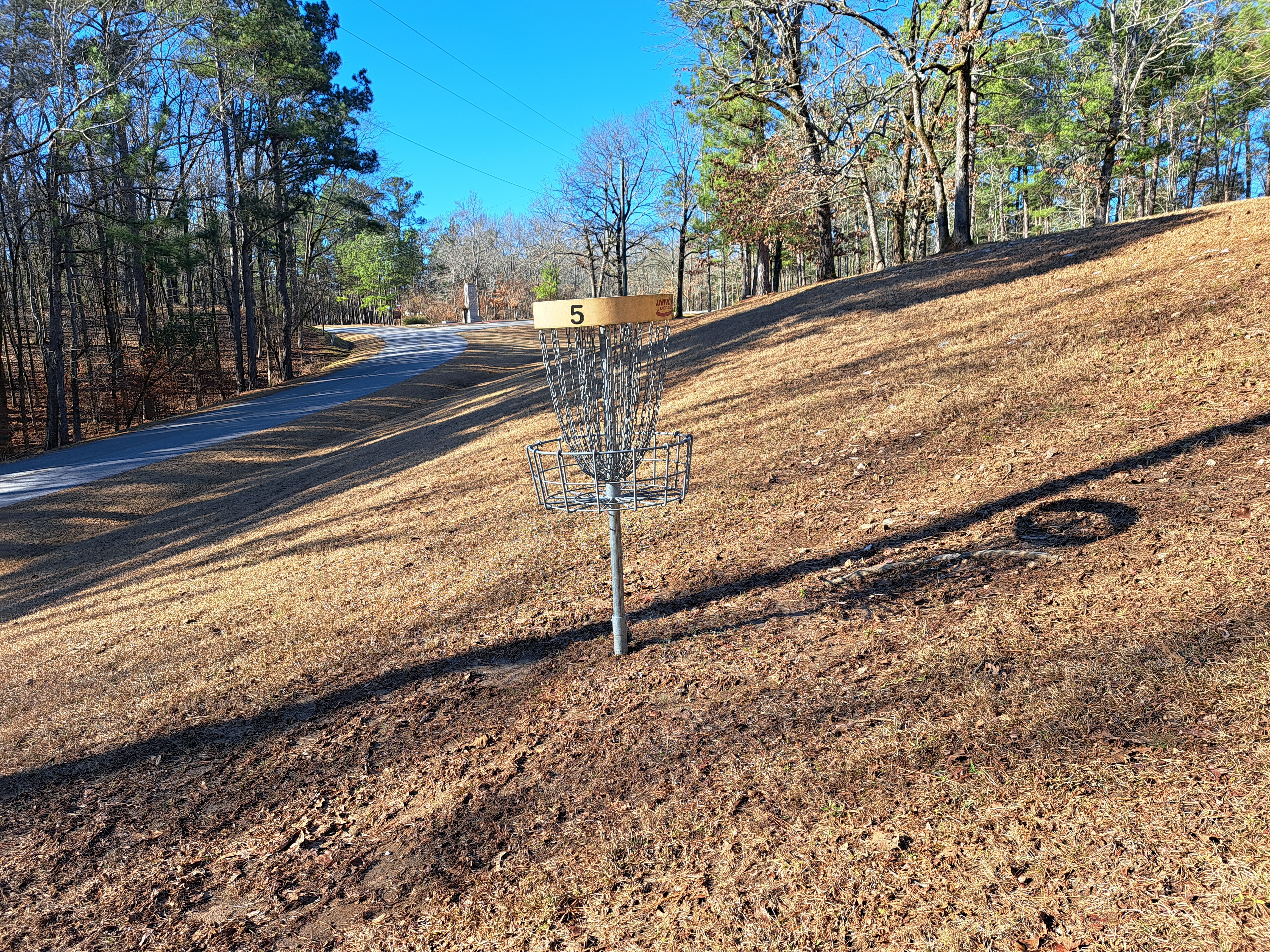
Comments: another boring open hole with no obstacles except a significant left to right cross slope.  The park road to the right will not come into play with a decent throw.  #6 tee is uphill to the left.

Hole #6: 171 feet, par 3
Comments: a downhill hole that plays through a smattering of pine trees, none of which stand directly between the tee and the basket.  A steep downslope behind the basket leads down to the park road, so take care not to overshoot.  #7 tee is to the left.

Hole #7: 174 feet, par 3
Comments: uphill and playing the opposite direction as hole #6.  Dense woods guard the inside of a slight dogleg right, so be careful biting off too much of the dogleg.  #8 tee is to the right.

Hole #8: 177 feet, par 3
Comments: there are no obstacles between the tee and basket on this slightly downhill hole, but dense woods guard either side.  While not a great hole by itself, this hole is a nice change of pace from the previous 6.  #9 tee is behind the basket.

Hole #9: 243 feet, par 3
Comments: now this is a finishing hole!  It plays sharply downhill and across a small drainage with the basket in a fairly open area.  The hill is steep enough that I was not comfortable walking down it, and some stairs would be very appreciated here.  A good first throw will set up a birdie opportunity to close your half-round.  The parking lot is located up the stairs behind the basket.

Tuesday, January 17, 2023

Wildcat Hollow Disc Golf Course at Pike Lake State Park near Piketon, OH

Basic Information

Course Location: Pike Lake State Park
Geographic Location: west of Piketon, OH (39.15903, -83.22616)
Date Visited: October 2022
Number of Holes: 18
Course Length: 3718/4785 feet, par 64
Cost to Play: free
Difficulty Level: intermediate
Carts: would be difficult to use here due to steep terrain
Potential to Lose Discs: medium due to dense woods; high if you play in the fall due to leaf litter
Course Walkabout Video, Front 9: 
Course Walkabout Video, Back 9: 

Driving DirectionsFrom Piketon, go west on SR 124 7 miles to Morgan Fork Road, a narrow paved road, and turn right on Morgan Fork Rd.  In 4 miles, where the road forks, bear left onto Pike Lake Road.  The park is 2 miles ahead.  Turn left onto Egypt Hollow Road at the park's main intersection and park in the perpendicular parking area beside the first picnic shelter on the right.  #1 tee is to the left of the picnic shelter.

Course Constructions:

Tees: 2 per hole; concrete back tee; unfindable front tee
Baskets: 1 per hole; in good shape on my visit
Signage: course map near parking area; hole sign on each tee
Amenities: benches on most holes, vault toilets, practice basket, picnic shelter, other amenities elsewhere in the park

Summary Review: 3.5 Stars (out of 5)

Built in 2004, the Wildcat Hollow Disc Golf Course at Pike Lake State Park is a once-great course that is now showing its age.  Located in a remote area, this heavily wooded course features a mixture of wild holes with extreme elevation change and flat straight-forward holes.  In general the "wild" holes play up and down the sides of Wildcat Hollow while the flatter holes play along the park road.  The course offers a nice mixture of short and long holes.  15 of the holes are heavily wooded with tight lines, which may be too many for some player's preference.  In theory there are 2 sets of tees, but on most holes I was unable to find the forward tee.  The course is organized into 2 loops, so you could play only 9 holes if the terrain becomes too much.  The hole signs look dated, but at least they exist.  Some of the pars also seem too high to me: they seem to date to an era of inferior equipment and player skill.  The course maintenance was fine except for a large amount of leaf litter that made footing tricky by covering rocks and roots.  In fairness, most of those leaves had fallen within a week or so of my visit.  For a middle-aged fat guy like me the terrain and bad footing made for a rough round, but I can see how a more athletic person might enjoy this course.  If you live in Cincinnati, Lexington, or Columbus and want a nice daytrip with some adventurous disc golf, then this course may be exactly what the disc golf course reviewer ordered.

Hole-by-Hole Review 

Distances taken from hole signs.  Picture sequence for each hole is 1) back tee, 2) approach, 3) basket to tee.

Hole #1: 230/345 feet, par 4
Comments: The first two holes play through the flatter area in the bottom of the hollow.  This lightly wooded hole is a slight dogleg right with a dry rocky streambed guarding the inside of the dogleg.  Given that this hole has a somewhat wide fairway, it should probably be a par 3.  (Aside: I will make several statements like the previous one in this review.  The inflated pars are not a big deal to me: they do not affect how you play the course.)  #2 tee is to the left.

Hole #2: 227/261 feet, par 4
Comments: a flat and straight hole, medium-sized trees guard either side of the fairway, which is wider than you would expect for a wooded hole.  Again, I would prefer this hole as a par 3.  #3 tee is across the road to the left.

Hole #3: 177/219 feet, par 3
Comments: now the course's wild side emerges as it heads up the steep sides of the hollow.  This hole plays across a dry creek and directly up a steep hill.  The tight fairway demands a long, accurate throw if you want to get close to the basket with your tee shot.  Some constructed wooden steps help you climb the hill, and they are very appreciated.  #4 tee is to the right.

Hole #4: 270/378 feet, par 4
Comments: a rolling hole that plays across the side of the hill.  The fairway has a left to right cross slope, and any disc missing right could go all the way down into the hollow.  The large number of trees make this a fairly tight hole as well.  #5 tee is behind the basket.

Hole #5: 165/248 feet, par 3
Comments: another heavily wooded uphill hole, but the slope is much more gradual than on hole #3.  This hole is also a slight dogleg left, and the large number of trees enforce the dogleg.  #6 tee is to the left.

Hole #6: 214/369 feet, par 4
Comments: kind of the inverse to hole #4, but there are also many differences.  The cross slope is not as severe, the drop-off into the hollow is not as close to the fairway, the basket is in a small ravine, and the fairway is wider.  The fairway is wide enough that this hole could be a long par 3.  #7 tee is to the left.

Hole #7: 168 feet, par 3
Comments: a dramatically downhill hole that does not play more than 120 feet.  A dry creek guards the front of the basket.  This hole would be ace-able except that the disc comes almost straight down on the basket.  This is the most memorable hole on this course.  #8 tee is to the right.

Hole #8: 303 feet, par 5
Comments: now the course returns to the flatter area at the bottom of the hollow.  This hole plays along an asphalt road, and the road basically acts as the hole's fairway.  This arrangement is problematic: the road is a public road open to vehicles, and I did see several vehicles on this road.  Thus, you have to watch for vehicles, not only for your disc flight but also for your personal safety.  A cluster of big trees directly in front of the basket forces you to fly your disc over the road to the left.  Also, this hole would be a better par 3 than a par 5.  This is my least favorite hole on this course and one of my least favorite holes anywhere.  #9 tee is behind the basket.

Hole #9: 220 feet, par 4
Comments: a flat hole through dense woods with a tight line.  You will either appreciate or hate the fact that this hole is much more conventional than some of its predecessors.  I would prefer this hole as a par 3.  #10 tee is beyond the vault toilets behind the basket on this side of the park road; the parking lot is across the road to the left.

Hole #10: 160/220 feet, par 3
Comments: a fairly flat and straight hole, this hole plays across a stream that was a dry rocky channel when I came here.  The channel also guards the basket on the left, so thoughtful and accurate throws are required on this heavily wooded hole.  To get to #11 tee, walk back to the bridge across the stream and head uphill on the purple-blazed Wildcat Hollow Hiking Trail a few hundred feet.  The tee is on the left side of the trail.

Hole #11: 160/250 feet, par 3
Comments: this dogleg right plays uphill, but the terrain is not nearly as steep as some of the holes on the front nine.  The fairway is surprisingly wide for a heavily wooded hole, and the area around the basket is quite open.  #12 tee is to the left.

Hole #12: 230/420/540 feet, par 5
Comments: this tee location gives you the top-of-the-world feeling much like the tee shot on hole #7, but that is where the similarities between holes #12 and #7 end.  Whereas hole #7 is the shortest hole on this course, this hole is the longest.  It is also a par 5, although I would prefer it as a par 4.  This hole is a sweeping dogleg right around the hollow's steep side on the right.  I thought about flying my disc over the end of the steep ridge to cut the dogleg, but I decided that shot was too risky: the large number of trees force accurate throws.  Though the terrain is not as steep, this hole is just as memorable as any on the front nine.  #13 tee is to the left and behind the basket.

Hole #13: 200/221 feet, par 3
Comments: a slight dogleg right and slightly uphill, the basket is located at the base of a steep hillside to the right.  The tight fairway requires an accurate throw.  #14 tee is behind the basket.

Hole #14: 191/240 feet, par 3
Comments: the good use of the hollow's steep side continues: this downhill hole doglegs right around the end of a ridge.  The basket is actually located behind the ridge as you view it from the tee; it is at the very base of the hillside.  As with hole #12, you could possibly fly your disc over the ridge to cut the dogleg, but that throw is risky due to the large number of trees.  This is another very memorable hole.  #15 tee is to the left and behind the basket.

Hole #15: 210 feet, par 3
Comments: the inverse of hole #10 in the sense that it plays back across the rocky channel with the channel guarding the basket on the right.  Also, several large trees grow less than 50 feet in front of the basket.  #16 tee is to the left.

Hole #16: 219 feet, par 4
Comments: after 6 holes surrounded by dense woods, you can see daylight from the park's open areas behind the basket while standing on the tee, but more dense woods will need to be negotiated with your tee shot to get to the daylight.  Despite the very tight line, to me it seems obvious this hole should be a par 3.  #17 tee is to the left.

Hole #17: 174 feet, par 3
Comments: although the line of play through the smattering of trees is tight, this is a flat and straightforward hole.  This is actually one of the more boring holes on this course.  #18 tee is behind the basket and across the park road.

Hole #18: 200 feet, par 3
Comments: the most open hole on this course.  A stream/rocky channel crosses directly in front of the tee and continues up the right side of the hole, guarding the right side of the basket.  This is a fairly tame ending to what can be a wild and wooly course.