Basic Information
Course Location: Chau Ram County Park
Geographic Location: west of Westminster, SC (34.68129,-83.14584)
Date Visited: April 2021
Number of Holes: 18
Course Length: 4461-5541 feet, par 55
Cost to Play: $2 park entrance fee
Difficulty Level: intermediate
Carts: a 10-15 minute trail walk to #1 tee and some very steep terrain make using a cart nearly impossible
Beginner Friendly? no
Potential to Lose Discs: medium due to dense trees and a creek
DG Course Review Page: https://www.dgcoursereview.com/course.php?id=12114
Driving Directions: From downtown Westminster , take US 76 west 3 miles to Chau Ram Park Road and the signed park entrance. Turn left on Chau Ram Park Rd. Drive another 0.3 miles to the parking area behind the (brand new in 2021) park office and Visitor Center. The trail that leads to #1 tee is uphill behind the park office and to the right; the start of the trail is pictured below.

Course Constructions:
Tees: most holes have 2; they are either elevated wooden platforms or rubber mats
Baskets: 1 yellow Innova disccatcher per hole; they are more or less brand new
Signage: signs on every tee, and signs pointing the way to the next tee
Amenities: none, although the elevated platform tees could also be used as benches
Summary Review: 3 Stars (out of 5)
Brand new in 2021, Chauga Rapids Disc Golf is disc golf on the wild side: it is laid out in the middle of nowhere on steep, heavily wooded terrain. The course route is well thought out, and a lot of time and work have gone in to building the tees and grooming the fairways. That said, there are some issues, not the least of which is the 10-15 minute uphill trail walk from the parking lot to the course itself. I have read about plans for a separate parking area at the course, a desperately needed improvement in my view. Also, the bare wood tee platforms are fine for now, but over time they will collect a thin layer of mud that will become very slippery; a surface offering better traction will be needed. Finally, some of the fairways are very steep, and repeated foot traffic will lead to soil erosion problems. Some switchbacks or steps are needed to help players navigate the steep areas. Overall, the 3 star rating reflects what the course is now, not the immense potential it has. You may or may not enjoy your round here now, and I left some room to improve the rating as the course continues to get improved.
Hole-by-Hole Review
Distances taken from hole signs. Picture sequence for each hole is 1) tee, 2) approach, 3) basket to tee.
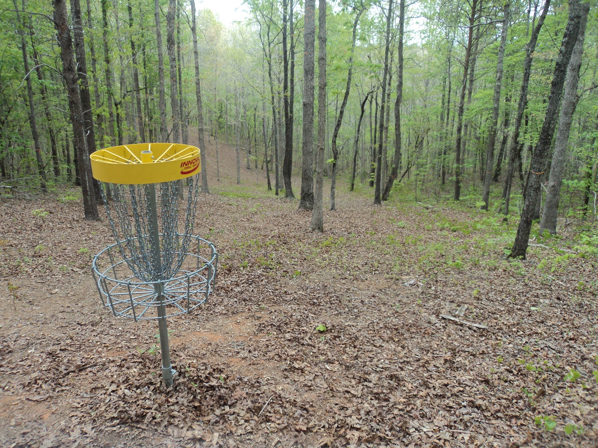
Hole #1: 228/136 feet, par 3


Comments: a gentle opening hole, it is flat and short with a fairly wide line of play. This hole gives no indication of the wildness that is to come. #2 tee is behind the basket.
Hole #2: 290/242 feet, par 3


Comments: the next two holes seem to drop off the edge of the world. With the high voltage power line to the right, this hole descends gradually at first but more steeply as you approach the basket. The basket sits on the side of the hill with dense brush just beyond. #3 tee is to the left and downhill.
Hole #3: 393 feet, par 3


Comments: a sweeping dogleg left, this may be the most downhill hole I have ever played: you will not find any flat spots until you get to the basket. Watch your footing as you make your way down the fairway. The basket sits at the very bottom of the hill. #4 tee is behind the basket and to the right.
Hole #4: 407/304 feet, par 3


Comments: now at the bottom of the ravine, this hole plays over a low ridge with a dogleg right. The creek on the right could come into play even though this fairway is wide relative to other holes on this course. The basket sits in a small flat clearing beside the creek. This hole is a nice change of pace from the steep holes preceding and following, and it may be my favorite hole on this course. #5 tee is behind the basket and to the left.
Hole #5: 220 feet, par 3


Comments: though short, this hole plays directly away from the creek, and therefore it plays directly up the steep hill. You have to pick your line of play carefully due to some trees in the fairway. #6 tee is uphill and to the left.
Hole #6: 284 feet, par 3


Comments: a dogleg right with the hill on the right, this hole is more sidehill than downhill. Thus, you can risk cutting off some of the dogleg knowing your disc will probably bounce down toward the fairway once it lands if you hit a tree. #7 tee is uphill behind the basket.
Hole #7: 197/135 feet, par 3


Comments: another short uphill hole similar to #5 and just as steep. #8 tee is uphill behind the basket.
Hole #8: 241 feet, par 3


Comments: the sign at the tee says this hole is supposed to have 2 lines of play, but right now only the higher one to the right is feasible; the left one is blocked by trees. If you miss left, your disc could roll a long way down the hill. #9 tee is uphill to the right.
Hole #9: 326/261 feet, par 3


Comments: now back on top of the hill, this hole is almost identical to #1 but playing in the opposite direction. One strategically placed tree stands in front of the basket. #10 tee is to the right.
Hole #10: 306/232 feet, par 3


Comments: the 3rd of 5 ridgetop holes, this hole is similar to the other 4 ridgetop holes but with a basket that is set to the left of the main path. It is amazing how unremarkable the ridgetop holes are relative to the hillside and ravine holes. #11 tee is behind the basket.
Hole #11: 677/340 feet, par 4


Comments: following the pattern of the front nine, the longest hole on the course is a steep sweeping dogleg left downhill hole. It is also the only non-par 3 on the course. The fairway is dotted with trees, so you have to pick your line of play carefully. #12 tee is behind the basket and to the left.
Hole #12: 326/270 feet, par 3


Comments: a sharp dogleg right, this hole rises slightly and then finishes the steep descent begun on the previous hole. Maybe I had fresher legs when I came here the second time to review the back nine, but the back nine did not seem as steep as some of the holes on the front nine. Dense trees, a steep hill, and a creek on the right discourage you from trying to cut the dogleg. #13 tee is to the left.
Hole #13: 264/166 feet, par 3


Comments: the back nine's version of hole #4. A nearly flat creekside hole, the tee shot from the back tee plays over a bend in the creek. The creek on the right could come into play with a bad throw. #14 tee is uphill to the left.
Hole #14: 236/182 feet, par 3


Comments: the next three holes are laid out in switchbacks up the hillside. This narrow hole plays over a small swale before climbing steeply to the basket. #15 tee is uphill to the right.
Hole #15: 263 feet, par 3


Comments: this hole is slightly wider than the previous hole but plays back over the same swale. The amount of cross-slope is surprisingly low considering the hillside. #16 tee is uphill to the left.
Hole #16: 322 feet, par 3


Comments: an uphill sweeping dogleg right, some trees had recently been removed when I played here to widen the line of play. The tree removal is a significant improvement in my view. #17 tee is behind the basket and to the right.
Hole #17: 266/175 feet, par 3


Comments: this uphill hole completes your ascent back to the ridgetop. It is a somewhat narrow and slightly uphill hole that winds its way through the trees. #18 tee is uphill behind the basket.
Hole #18: 295 feet, par 3


Comments: another fairly flat narrow hole that forces you to pick your line of play through the trees. As I commented on #10, it is amazing how mundane and repetitive the 5 ridgetop holes are compared to the steepness and wildness of the 11 hillside and 2 creekside holes. Maybe this course should start and end at the bottom of the ravine?
No comments:
Post a Comment